
Dam Fm
Type Locality and Naming
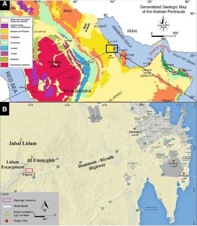
The Dam Formation is named for Jabal al Lidam (Fig. 1), Saudi Arabia (lat. 26°21'42"N, long. 49°27'42"E) where the lower part of the type unit crops out. Lower beds of the formation were measured in the east face of Jabal al Lidam and the upper part of the 294.6 ft. (89.8 m) interval at Al Umayghir (lat. 26°17'15"N, long. 49°30'24"E) (Powers et al. (1966), (Table 1). Used for the first time by Steineke M. and Kock T.W., in an unpublished 1935 report, Saudi Arabia and formally described later by Powers (1968) in Saudi Arabia and Cavelier (1970a) in Qatar.
[Figure 1: Location of the Type Section of the Dam Formation at Jabal al Lidam; modified from Chan et. al. (2017)]
[Table 1: Dam Formation type section measured and described by Max Steineke and T.W. Koch at Jabal al Lidãm Saudi Arabia in an unpublished 1935 report, and formally described by Powers et al. (1966) and Powers (1968)]
Synonym: Lower Fars Fm, ?”Hadrukh Formation” and “Dam Formation”, Steineke, Bramkamp and Sander, 1958. “Fars”, Dominguez, 1965.
Reference section:
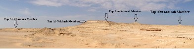
Surface location at Jebel Al-Nakhash (lat. 24°52’25.07 N, long. 50°54’12.81 E) (Fig 2)
[Figure 2: The Dam Formation exposed on the east side of “Jebel Al-Nakhash” along Salwa Road in SW Qatar (lat. 24°52’25.07 N, long. 50°54’12.81 E); LeBlanc (2015a). At that location, the Abu Samrah Member is also capped by about 3.3 ft. (1 m) of gravel from the Mio-Pliocene Hofuf formation.]
Lithology and Thickness
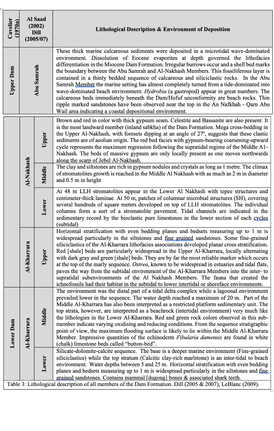
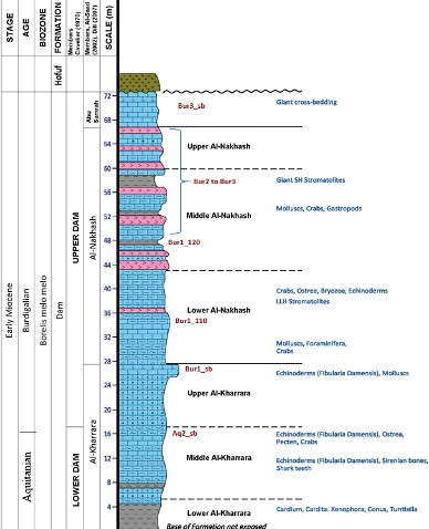
Cavelier (1970a) and Cavelier 1975 describe the lithology of the Dam Formation outcropping in Qatar over the Hazm Mishabiyah area (Lat. 24°44'16.13"N and Long. 50°53'43.14"E) (Fig. 4) and split this rock unit into Lower and Upper. Al-Saad et al (2002a) constructed a Geological Section of the Jebel Al-Nakhash, which contains the most representative column of the Dam Formation in Qatar (Fig. 3). Dill et al. (2005) and Dill et al. (2007) subdivided the succession of sedimentary rocks belonging to the Dam Formation over the Jebel Al-Nakhash area into seven lithofacies associations (Fig. 3). These lithofacies associations were stratigraphically grouped by Dill et al. (2005) from top to bottom into three members called Abu Samrah, Al Nakhash, and Salwa Members (Dill's Salwa Member was renamed as “Al-Kharrara” in the present document, as per Al-Saad et al. (2002a), due to conflicting nomenclature since the name “Salwa” was already used as a member of the Cretaceous Simsima Formation). Al Nakhash and Al-Kharrara Members both allowed for a refinement of the stratigraphy as each is comprised of an upper, middle, and lower unit. It is this tripartite sub-division that is being used in the present publication (Fig. 3, Table 2, Appendix E). 72 m (236 ft) over Jebel Al-Nakhash of easily identifiable sections. Cavelier (1970a) also reported a thickness of about 78m (256ft) over the massif 1.5 km NNE of the Qarn Abu Wail , however because this location is too close to the Qatar/Saudi Arabia border it is not selected as the reference type.
[Figure 3: Stratigraphic column at Jebel Al-Nakhash (Lat. 24°52’25.07 N, Long. 50°54’12.81 E) showing the Lower & Upper Dam Formation of Cavelier (1970a) and the more specific subdivisions established by Dill et al. (2007) & Al-Saad et al (2002a); modified by LeBlanc (2015a). Grey = shale, Blue = limestone, Pink = gypsum, Sb = Sequence boundary, Bur = Burdigalian, Aq = Aquitanian, Bur3 = 18.7Ma, Bur1 = 20.5Ma, Aq2 = 22.2Ma]
[Table 2: Lithological description of all members of the Dam Formation. Dill (2005 & 2007), LeBlanc (2009)]
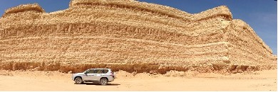
[Figure 4: A representative section cutting through the Upper Al-Kharrara and Lower Al Nakhash Members of the Dam Formation over the Hazm Mishabiyah.]
Relationships and Distribution
Lower contact
Upper contact
It is overlain by the Late Miocene to Early Pliocene conglomerate and sandstone of the Hofuf Fm (LeBlanc, 2008).
Regional extent
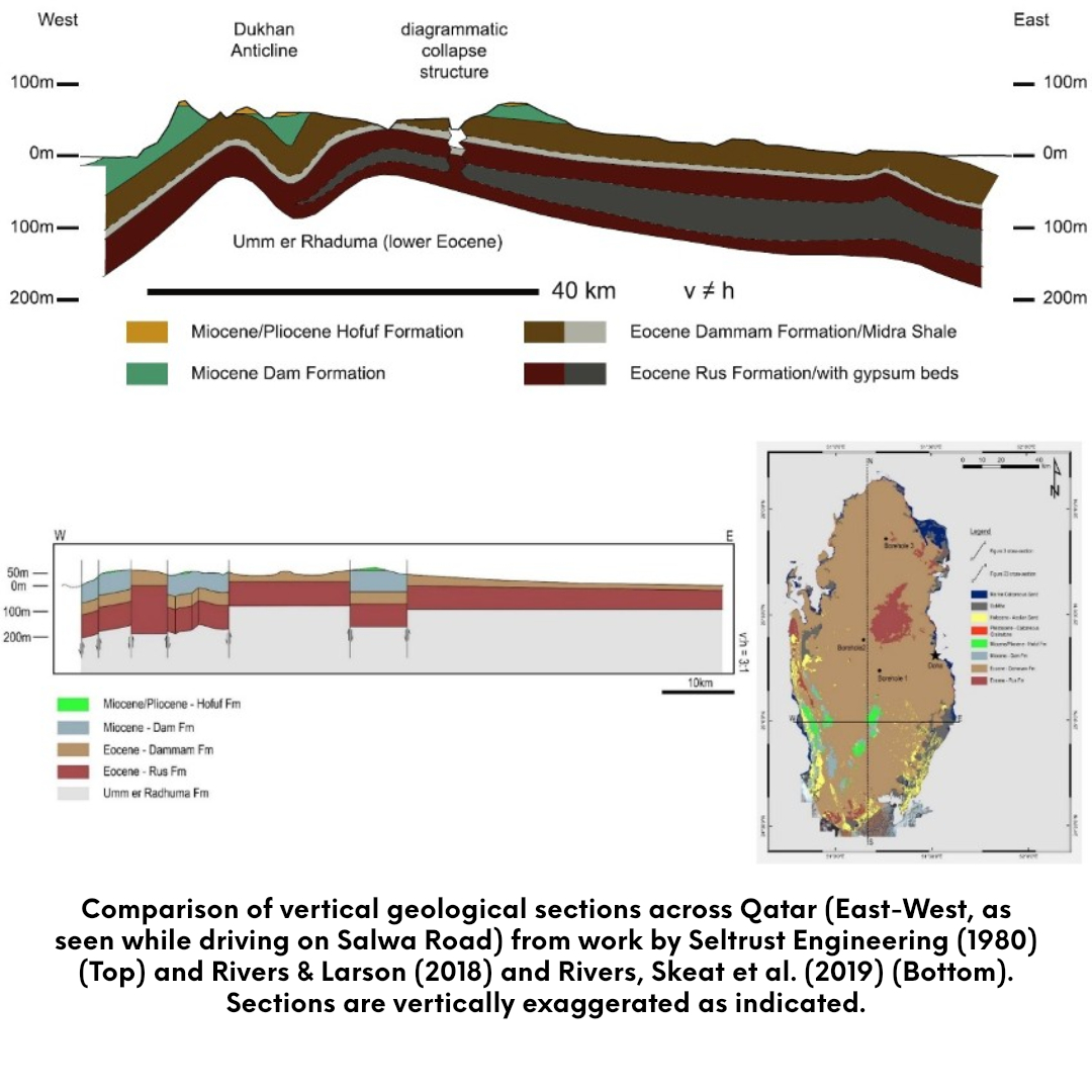
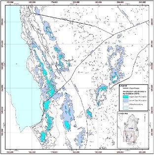
In Qatar, the Dam Formation is present in two discontinuous belts in the southwestern part of the peninsula and forms some of the highest ground (Figs. 5 & 6). The more western belt extends southwards, on both sides of the Dukhan anticline, from the vicinity of Umm Bab to the border beyond Abu Samrah. The second group of outcrops extend from north of Sawdaa Natheel northeastwards to beyond Al Kharrarah and nearly to the main Doha-Abu Samrah Road. Dam Formation rocks are also preserved in post-Miocene collapse structures such as at Karanah, Al Markhiyah and Mukaynis (Seltrust, 1980). The present-day occurrences of the Dam Formation are directly related to the uplift of the Qatar Arch (a broad, gentle anticline draping a major block uplift which caused Qatar to emerge from the Gulf). New observations by Rivers & Larson (2018) and Rivers, Skeat et al. (2019) favor a fault-controlled model for the Dukhan structure in the western part of the peninsula over an earlier fold-related and regional erosion model by Seltrust Engineering (1980) (Fig. 5). The effect of gypsum dissolution in the underlying Rus Formation was also a factor. Top: From 0 metre by the shore in SW Qatar to 84.6m above sea level on top of Al-Nakhash.
Dam Fm is equivalent to the Lower Fars Fm of Iran. The equivalent of the Lower Fars of Qatar should probably be sought in the Dam Formation of neighbouring Saudi Arabia, which yields a similar fauna and has been compared (R.W. Powers, 1968) with the Lower Fars Formation.
The Lower Fars of Qatar passes eastwards into the thick Fars succession seen in offshore Qatar and the Trucial States, where it is predominantly formed of gypsum-anhydrite. In Bahrain, sandy limestone, soft grey clays and marls, assigned to the Miocene, are believed to be equivalent to the Lower Fars
[Figure 5: Comparison of vertical geological sections across Qatar (East-West, as seen while driving on Salwa Road) from work by Seltrust Engineering (1980) (Top) and Rivers & Larson (2018) and Rivers, Skeat et al. (2019) (Bottom). Sections are vertically exaggerated as indicated.]
[Figure 6: Map of the Miocene rocks of Qatar. The Dukhan Anticline extends in NNW–SSE direction along the western coast of Qatar.]
GeoJSON
Fossils
In the Lower and Middle Al-Kharrara Members:
The molluscs are very abundant, with Ostrea latimarginata Vredenburg, sometimes common, are also found Pectinidae, Anomia, Spondylus, Lima, Avicula… and impressions and molds of Clementia papyracea (Gray), Diplodonta, Chama gryphoides Linne, Venericardia, Trachycardium, Veneridae…. and very locally some Cyrenidae.
The Gastropods, generally found as impressions, include Fissurella, Natica, Xenophora, Turritella, Cerithidae, Cypraea, Conus, Bulla… and very locally some Hydrobia, Potamides, and other brackish water genus.
The Echinoderms are very common but relate primarily to the small species Fibularia damensis, especially characteristic of the top of the Middle Al-Kharrara.
The Bryozoa corresponds to species not yet described: Steginoporella(?) sp., Thalamoporella n.sp. 1 et n.sp. 2.
Sirenian/dugong bones (mainly vertebrae and ribs, however a Palatal view of right posterior corner of a skull, exactly at the squamosal, part of the pterygoid and part of the palatine was discovered in 2009 and a possible skull roof in 2017) are common in the Lower and Middle Al-Kharrara Members and less so in the Upper Al-Kharrara. A “graveyard” exists on the eastern side of Hazm Mishabiyah in the Lower Al-Kharrara (LeBlanc, 2009).
Marine mammals, other than sirenians, were also present during the Lower Miocene, as they are today, attested by the author’s discovery of a tooth from a toothed whale (dolphins/tortoises) in the Middle Al-Kharrara.
The fishes are not common: Aetobatus arcuatus Ag. (genus of eagle rays) and Diodon sp. Indet. (Porcupine fish), and rare shark teeth normally associated with the remains of sirenians, as well as some remains of Reptiles(?) according to Cavelier (1970a, 1970b).
The algae are locally abundant: Halimeda eocenica Morellet.
Let’s note finally the frequence of Crustacean remains and the abundance of Large Foraminifera of the genus Archaias. The corals occur very locally at the extreme base.
From the Upper Al-Kharrara to the Abu Samrah Members:
In the synclinal area of the town of Abu Samra, the deposits display essentially marine features, with intercalations in the upper half, of organogenic limestones, with loads of Clausinella ersica Cox (a bivalve) and locally some Hydrobiidae (fresh & brackish mud snail – gastropod), indicating an environment abnormal in salinity. Towards the North and Northeast, these levels with Clausinella persica make up the major part of the subformation, Here much thinner.
The Molluscs from the marine layers, where the bivalves (clams) predominate, include Chlamys senatoria (Gmelin), Anomia sp., Ostrea latimarginata Vredenburg and impressions and molds of Clementia papyracea (Gray). Capsa lacunosa (Chemn), cf. Capsa fragilis (Linne), Tellina (peronidia) bipartita basterot, Diplodonta cf. rotundata (Montagu), Barbatia barbata (Linne), Anadara cf. turonica (Dujardin), Cardiocardita cf. monolifera (Dujardin), Cardiocardita aff. Turonica (ivolas et Peyrot), Solenocurtus basteroti (Desmoulins), Timoclea (Venus) subspadicea (Cossm), Modiola (Amygdalum) sp., some Cardium, Lucina, Mactra, Tapes, Eastonia, Panopea… The Gastropods, represented by internal molds, belong to the genus Xenophora, Ampullina, Turritella, Cerithium, Cypraea, Cassis, Fasciolaria, Voluta, Conus, ?Olivella, Bulla…
The Echinoderms are abundant at certain levels: in the Upper Al-Kharrara Schizaster sp., Agassizia aff. Persica Olegg and locally in the Middle and Upper Al-Nakhash are abundant spines of Cidaris sp. 1 de Noetling 1901.
The Bryozoa are not very common, among them ?Cupuladria gr. haidingeri, as well as remains of fishes: Scoliodon (or Physodon) sp. (shark)
The remains of Crustaceans are abundant in the carbonate rocks.
Age
Depositional setting
The Dam Formation in Qatar represents, from bottom to top, a succession of offshore marine sediments to continental sabkha deposits; Dill et al. (2005). Calcareous and evaporitic sediments (gypsum, celestite) of the Dam Formation in Qatar reflect deposition under subtidal through supratidal conditions, which towards the base and the top of the series grade into a modern beach deposit. All carbonate and siliciclastic sediments younger than the Middle Al-Kharrara were subjected to strong dolomitization, excluding the uppermost part of the Abu Samrah Member; Dill et al. (2007).
Additional Information
The Miocene sediments of Qatar are a marginal development of the thicker more typical Fars deposits which occur in neighbouring areas. The unit can be traced in a continuous development to its type area in Iran.
The name Lower Fars was first used in Qatar by Shaw and Cox in 1933 and has been retained ever since. Its synonymy with the Dam Formation of Saudi Arabia is suggested by the use of that name for the Miocene of South Qatar on U.S.G.S. Geological Maps.
https://doi.org/10.37819/biosis.001.04.0134 (or via https://sites.google.com/site/leblancjacques)